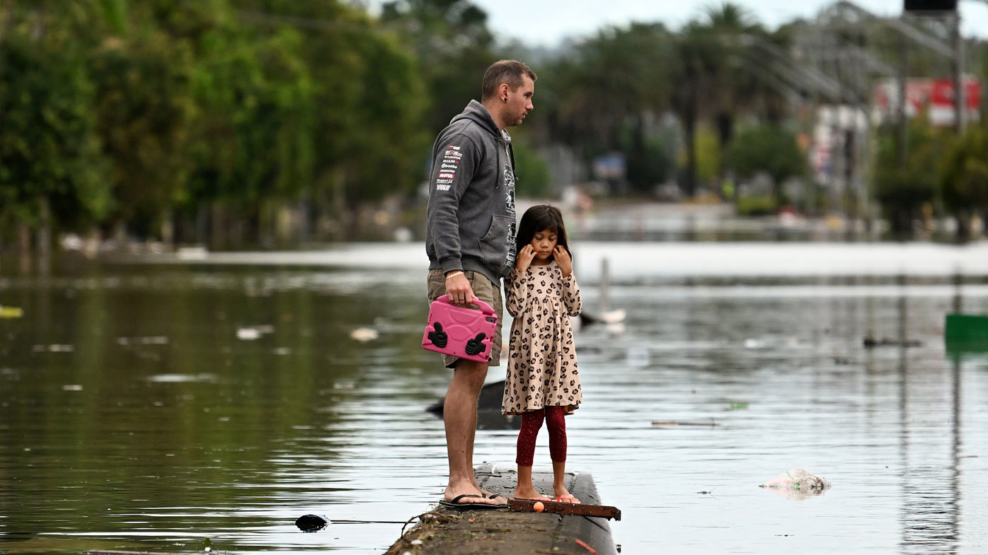
Over the last three years, the La Niña weather event brought cool temperatures and record-breaking rain to Australia's east, but there's now a good chance we'll move straight into an El Niño event this summer.
The Bureau of Meteorology (BoM) is anticipating La Niña will finish in February, and long-term models indicate conditions in the Pacific will get hotter and drier as the year goes on.
So what exactly is going on with Australia's weather, and what is going to happen next? We answer all of your La Niña and El Niño questions.
READ MORE: The global water cycle is changing and that spells bad news
Has La Niña ended in Australia?
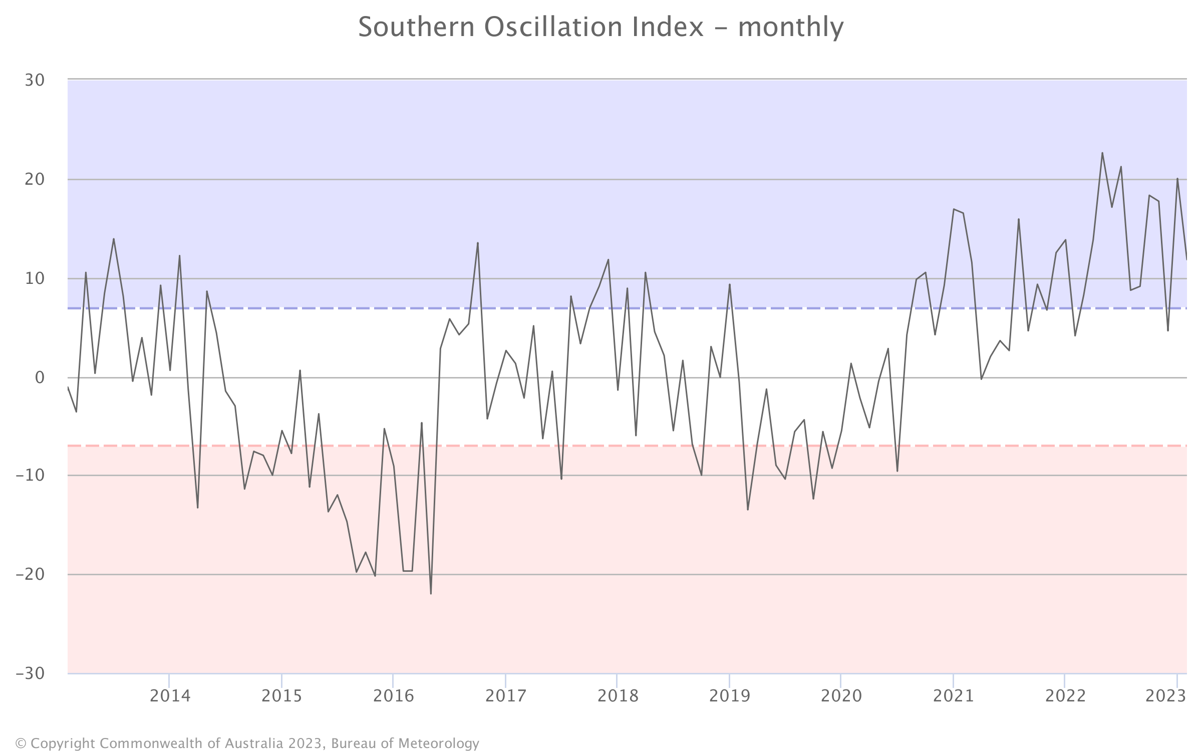
Not yet, but it's not far away. The BoM says the third consecutive La Niña will probably end this month.
In their latest climate driver update, published on January 31, it anticipates the system will ease during the last few weeks of summer.
"While ocean temperatures have eased from La Niña thresholds, the atmosphere has yet to respond, and remains La Niña-like," it said.
"All models anticipate sea surface temperatures in the central Pacific will return to neutral ENSO levels during February, with neutral conditions (neither La Niña nor El Niño) anticipated until at least mid-autumn."
How long has Australia had La Niña?
La Niña has been declared the in each of the last three summers, with conditions returning to neutral in between every time.
In most cases, La Niña events will appear for one summer, or sometimes twice in a row. This summer's third consecutive event was only the third time since 1950 there has been a "triple-dip" La Niña.
READ MORE: Dramatic climate swing 'likely' for next summer
What to expect from Australia's weather in 2023
With La Niña expected to subside over the coming weeks, the long-term weather forecast suggests things could go back to "normal" – although we'll get warmer than usual temperatures soon.
The BoM predicts that most of the country will likely see "higher than median temperatures between March and April". The exception will be the Central Coast of NSW, which should be slightly cooler than average.
But with La Niña over, an average of international models suggests its hot, dry counterpart, El Niño, could be close to returning in June, when sea surface temperatures are predicted to be 0.6°C above average.
If that prediction comes true, there may be below-average rainfall over the winter and spring of 2023.
Click through the interactive below to see the BoM's predictions for La Niña and El Niño throughout the year.
READ MORE: 2022 was fifth or sixth warmest on record as Earth heats up
What is El Niño and how is it different to La Niña?
The cycle of La Niña and El Niño – known as ENSO, or the El Niño-Southern Oscillation index – works a bit like a pendulum.
La Niña occurs when water in the eastern tropical region of the Pacific Ocean is cooler than average as the "trade winds" – the planet's prevailing east-to-west winds – strengthen, creating warmer-than-normal water around Indonesia and Australia's east coast.
This leads to increased rainfall and brings the risk of heavy flooding in Australia.
However, when those conditions are reversed – trade winds are weaker, and water is warmer than average in the eastern tropical Pacific but cooler close to Australia – an El Niño is declared, and our continent will experience hot, dry conditions and come under the threat of drought.
When the "pendulum" sits in the middle and ocean temperatures are closer to average, it is referred to as "neutral" ENSO conditions – and it is more likely to bring less extreme weather conditions.
And, if you're wondering what the two terms actually mean, "La Niña" is Spanish for "the girl" or "little girl", while "El Niño" translates to "the boy" or "little boy".
READ MORE: Australia's public holidays for 2023 and 2024 – Make the most of your annual leave
Will 2023 be an El Niño year for Australia?
There is some evidence indicating an El Niño will be declared by summer 2023.
The BoM says international modelling indicates water temperatures will be 0.6°C above average in June, putting the Pacific on the verge of an El Niño.
According to one climate expert, this could lead to a summer of drought, heatwaves and bushfires at the end of the year.
When was the last time Australia had an El Niño?
Australia's last El Niño event occurred during the summer of 2019/2020.
The country had a severe drought throughout 2019, and the strong El Niño system was partly responsible. The 2019 drought was measured by the Bureau of Meteorology to be Australia's most intense ever recorded.
It was then followed by one of the most dangerous bushfire seasons.
Before 2019-20, the previous strong El Niño event impacted Australia from 2014 to midway through 2016.