Millions of Australians across Queensland and northern New South Wales are bracing for tropical Cyclone Alfred to make landfall in the next 48 hours.
More than four million people, from Sandy Cape to Grafton, have been warned that the storm is expected to strike by Friday morning, bringing intense rainfall, dangerous winds, and the potential for flash flooding.
Here's everything you need to know about when and where Cyclone Alfred is predicted to strike.
LIVE UPDATES: Fears cyclone 'storm surge' could see tides flood thousands of homes
When will Cyclone Alfred make landfall?
Cyclone Alfred is still predicted to make landfall on Thursday night or Friday morning.
Senior meteorologist Christie Johnson said the storm was currently forecast to cross the coast at 1-2am on Friday, though that could possibly be off by one or two hours either side.
Residents living between the Sunshine Coast and the Gold Coast, including those in Brisbane, are in the firing line.
9News understands Alfred's speed has also picked up, to about 17km/hr.
Damaging wind gusts up to 130km/h are expected to lash the southeast Queensland and northeastern New South Wales coasts starting from Wednesday.
Meanwhile, destructive wind gusts of up to 155km/h may develop about coastal and island locations near and to the south of the track from Thursday afternoon.
There have also been large swells over 7m already recorded.
Heavy rainfall will come next, with possible daily totals of 200 to 400 millimetres, and could cause flash-flooding.
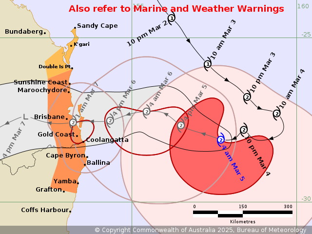
Australians can track the storm's predicted path on the BOM website, which hosts regularly updated 'track maps'.
At the time of writing Alfred was sitting 465 kilometres east of Brisbane, the bureau told media Wednesday in Queensland's capital.
READ MORE: How to prepare for Tropical Cyclone Alfred and what to expect
Where is Cyclone Alfred likely to hit?
Cyclone Alfred is expected to affect the southeast Queensland coast and some parts of northeast New South Wales.
The Bureau of Meteorology currently lists the areas from Double Island Point to Grafton as 'warning zones', including Brisbane, the Gold Coast, Sunshine Coast, and Byron Bay.
However, the warning zone does not include Grafton.
A 'watch zone' is current for Sandy Cape to Double Island Point in Queensland, including K'gari.
The northern NSW towns of Ballina and Lismore are also preparing for the cyclone.
However, the effects of the cyclone – especially strong winds – may extend beyond the currently listed regions.
READ MORE: 'Window is closing': Queenslanders urged to act as cyclone approaches coast
What time will Cyclone Alfred hit Brisbane?
Cyclone Alfred is currently predicted to hit Brisbane late on Thursday night or early Friday morning, bringing damaging winds, intense rain and possible flooding.
READ MORE: Will Tropical Cyclone Alfred impact flights this week?
How far is Cyclone Alfred from Brisbane?
As of Wednesday morning, Cyclone Alfred is building about 465 kilometres east of Brisbane.
At the time of writing, it is listed as a category 2 storm with wind gusts near the center hitting up to 130km/h.
BOM will continue tracking the storm as it creeps closer to the coast.
DOWNLOAD THE 9NEWS APP: Stay across all the latest in breaking news, sport, politics and the weather via our news app and get notifications sent straight to your smartphone. Available on the Apple App Store and Google Play.