After a relentless period of rain, skies are about to clear in Sydney today bringing a glimmer of relief to communities devastated by New South Wales' worst floods in more than a decade.
The rainfall total for the six-day event from Thursday to Wednesday in Sydney will be in the vicinity of 250mm to 350 mm in most suburbs.
The extreme conditions have resulted in several new records, with Penrith receiving 400mm this month – just under double its previous record of 230.2mm.
READ MORE: Young family tossed into floodwaters during Hawkesbury River rescue
This is roughly equivalent to two-thirds of Melbourne's annual rainfall in five days.
The weather around the state is forecast to flip today with full sun and temperatures of up to 30C in Sydney, Newcastle, Lismore and Coffs Harbour.
Despite the welcome change, major flood warnings remain in place and the danger for people in low-lying suburbs is far from over.
Of particular concern is the NSW town of Moree where evacuation orders are currently in place.
https://twitter.com/LiveTrafficNSW/status/1374436512809381894
The town of Singleton in the Hunter region, is also yet to see flood waters peak with levels expected to surpass 11m later today.
Even as the rain clears further today, flood risks remain high thanks to swollen rivers. Damaging winds are expected to cause problems, particularly in the Blue Mountains region.
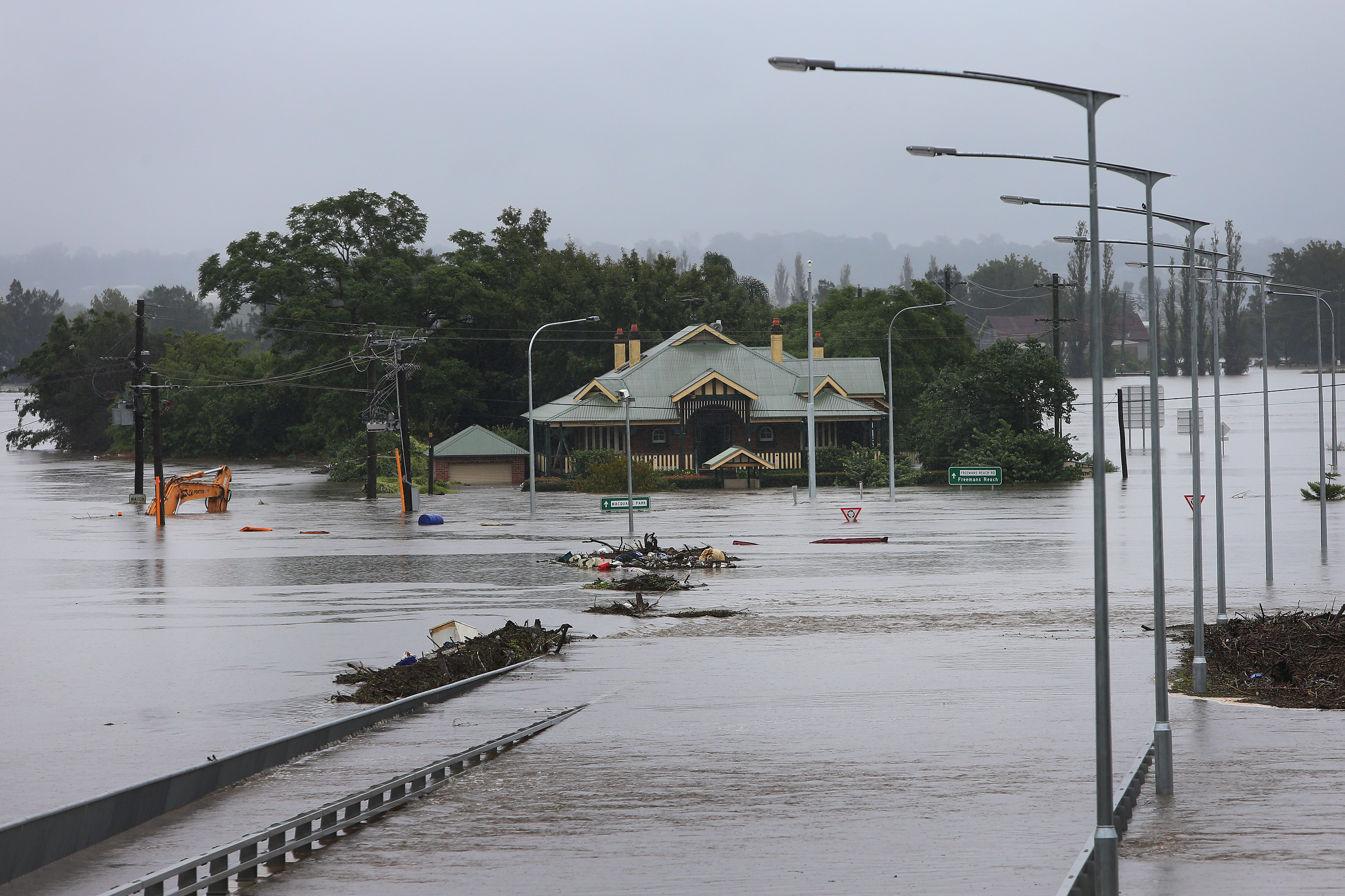
Residents in Windsor also remain on high alert after the Hawkesbury River continued to rise overnight with more homes engulfed by floodwaters.
The river is currently sitting at a height of around 13m with levels unlikely to receded for several days.
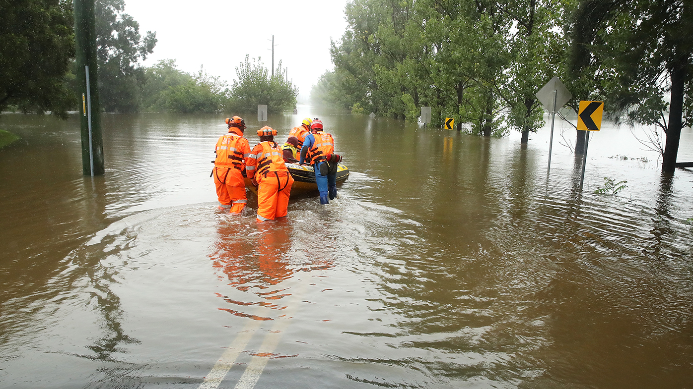
Authorities managing the disaster are shifting their focus gradually further south, as tens of thousands remain affected by burst rivers, landslips and power outages across the state.
South-east Queensland and much of coastal Victoria are also facing their own flood challenges.
Across NSW, more than 40,000 people have been affected by evacuation orders and almost 7000 were without power early on Wednesday morning, according to the NSW State Emergency Service.
Volunteers have been called to more than 1500 jobs in the past 24 hours, more than 80 of those being flood rescues — including a young family tossed into the Hawkesbury River when a rescue boat overturned.
"We have several areas that we will be watching today," NSW SES media officer Ilana Pender-Rose told 9News.com.au.
READ MORE: Pet emu rescued from floodwaters in the Hawkesbury
"Now, just because the rain has stopped doesn't mean the rivers won't rise.
"And it is going to take quite a long time for that water to come down, especially around the Hawkesbury-Nepean Valley.
"So we're asking people just to please have patience. And please be safe."
Ms Pender-Rose warned the "supersaturated" soil and high winds could combine to increase the risk of landslips, which had already proved to be a problem in parts of the Central Tablelands.
https://www.facebook.com/PaulTooleMP/posts/3527780430682228
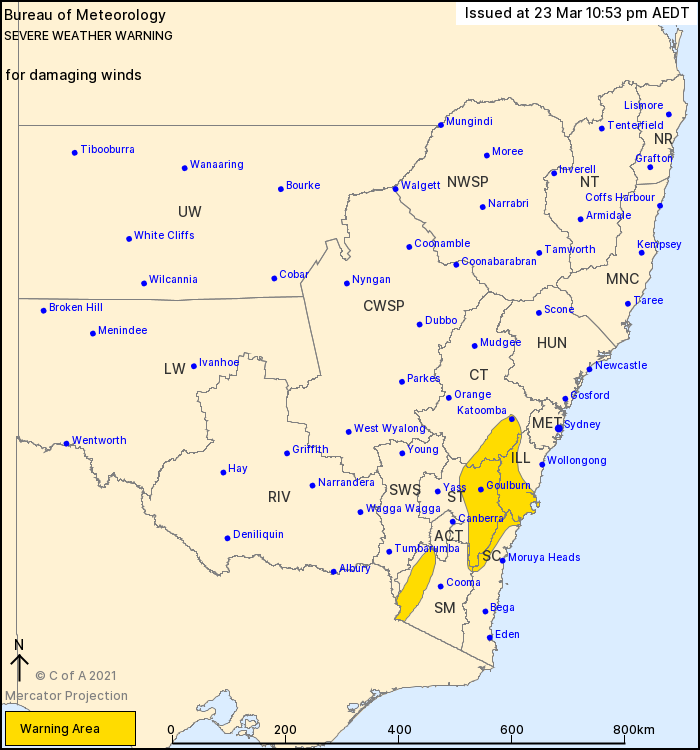
A severe weather warning remained current for parts of the Illawarra, South Coast, Central Tablelands, Southern Tablelands and Snowy Mountains regions on Wednesday morning.
They were warned to expect wind gusts of up to 100km/h and damaging surf on the coast while Bowral, Perisher Valley, Thredbo and other parts of the Southern Highlands above 1900 metres were told to brace for gusts in excess of 125km/h.
Forecasters believe the worst of the rain has passed into Victoria, but not before dumping more than a metre of water in parts of the Mid North Coast such as Mount Seaview and Comboyne.
While some flood danger zones have been declared safe to return to, residents were still facing fresh threats on Tuesday evening, with evacuation orders issued for low-lying parts of Moree and Southgate, which has expired.
"In western New South Wales, once rivers get going, they can keep flowing for weeks or months on end," the Bureau of Meteorology's Victoria Dodds said.
READ MORE: Queensland farm swept away in extreme south-east downpour
Across the border in Victoria, the whole coastline from Mallacoota west to Sorrento was warned to expect heavy rainfall that could lead to flash flooding and damaging winds similar to the NSW South Coast.
The bureau expects possible rain dumps of between 150 and 200 millimetres around the Strzelecki Ranges and Wilsons Promontory from Tuesday evening into Wednesday night.
In Queensland, the Gold Coast was "ravaged" by intense flooding as the rain refused to clear on Tuesday, with more storms possible on Wednesday morning.
Flood warnings were current for parts of more than a dozen river systems.