There are more signs an El Niño weather pattern is developing in the Pacific Ocean, raising the likelihood of warmer and drier winter for large parts of Australia.
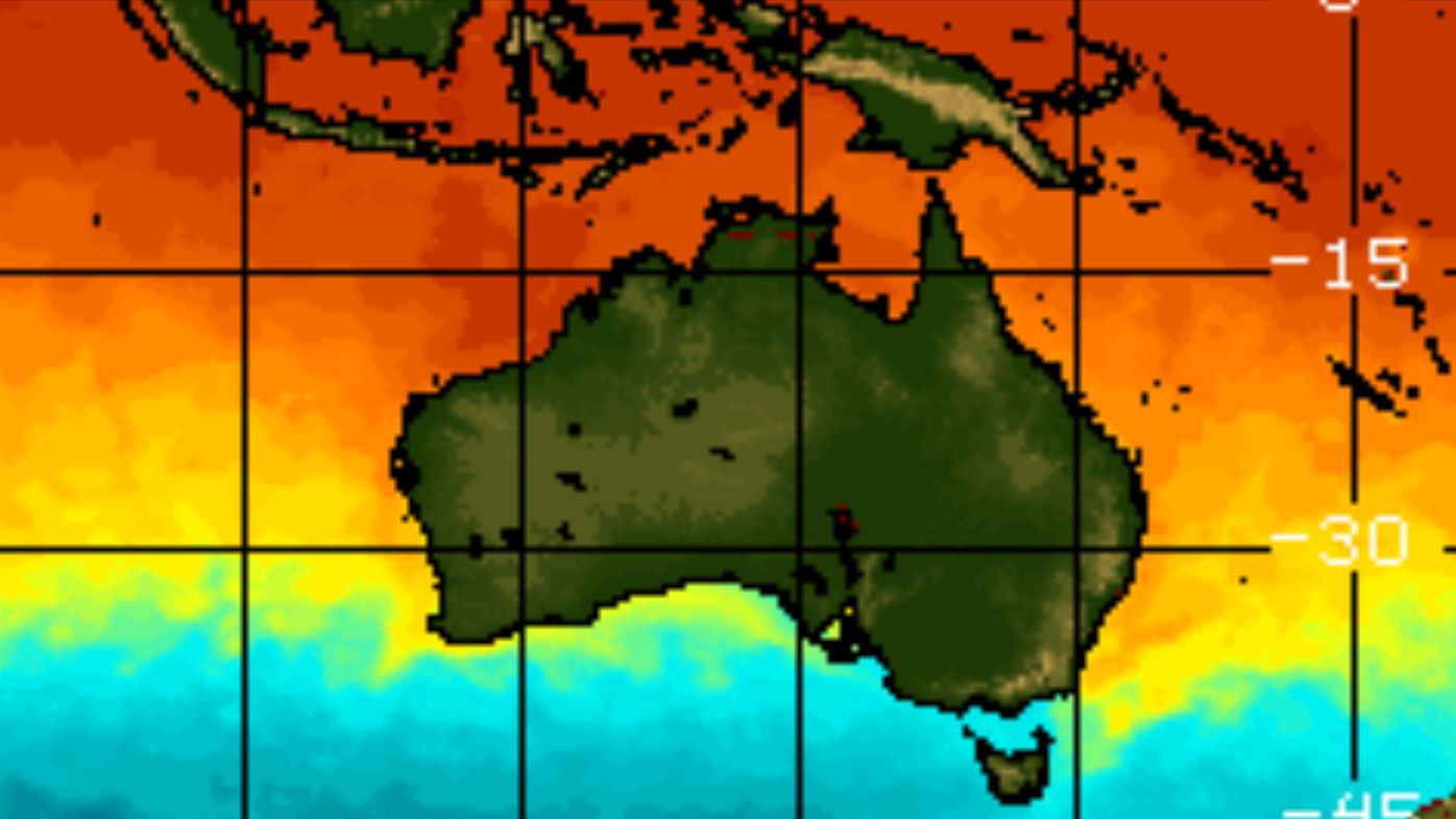
Ocean temperatures in the tropical Pacific Ocean have rapidly warmed towards El Niño levels over past weeks, reports weather channel Weatherzone.
New data shows the seas have warmed swiftly this month, rising by 0.5 degrees in the past two weeks, and 0.3 degrees in just one week.
LIVE UPDATES: King Charles addresses US Congress
El Niño — the climate condition when seas are unusually warm — can upturn regular weather patterns in winter and spring.
Research over the past months has pointed to this year's El Niño becoming one of the most powerful on record, with forecasters predicting it could reach a "super" level.
But experts say the ocean warming will have to gather further strength over several more months for it to become an official El Niño event.
Another component of El Niño is how the atmospheric temperature responds to a warming ocean.
Forecasters say the air above the tropical Pacific Ocean is now showing signs of the weather pattern.
READ MORE: Trump thrills in 'royal ties' as he welcomes King to White House on historic day
"The 30-day Southern Oscillation Index (SOI) – a measure of atmospheric pressure difference across the tropical Pacific – dipping below –10 in the past week," says Weatherzone.
"This is well below the El Niño threshold of –7, however, these negative values will need to be sustained for at least several weeks to qualify as an El Niño signal."
The weakening strength of easterly trade winds over the western Pacific Ocean is another sign of a developing El Niño.
What could happen in Australia?
While El Niño can happen without any major weather changes, it makes some conditions more likely in winter and spring.
Records over the past decade show huge parts of eastern Australia usually experience less rainfall and higher-than-average seasonal temperatures outside tropical regions during El Niño.
Mornings in winter and spring can be unusually cool due to clearer skies.
Spikes in temperature also bring greater evaporation, and together with lower rainfall, raises the risk of drought in some parts.
Lower snow depths in alpine regions also raises the chance of a shorter ski season.
But meteorologists at Weatherzone say even with a stronger El Niño, these conditions in the coming months are far from certain.
NEVER MISS A STORY: Get your breaking news and exclusive stories first by following us across all platforms.
- Download the 9NEWS App here via Apple and Google Play
- Make 9News your preferred source on Google by ticking this box here
- Sign up to our breaking newsletter here