Tag Archives: oceania

'Extremely dangerous' tornado leaves 100 million people in the US on alert

A "large and extremely dangerous" tornado has left people with serious injuries and caused significant damage in parts of Alabama in the United States.

National Weather Service (NWS) in Birmingham, Alabama, said Jefferson County and surrounding areas were thrashed by the tornado on Monday night, including ripping through a hotel and tearing off part of the roof of a church.

Jefferson County Coroner Bill Yates confirmed at least one fatality related to the tornado with search and rescue operations are still underway.

READ MORE: Tropical cyclone watch issued for Far North Queensland

Injuries ranging from minor to serious have been reported with victims transported to area hospitals, Jim Coker Director of Jefferson County Emergency Management Agency (EMA) told CNN.

He did not say how many people were injured.

Mr Coker told CNN the damage from the tornado is "considerable," which "hit a heavy retail and residential area."

A house collapsed on a family, but their condition is not known at this time, Mr Coker said.

There are five fire department heavy rescue teams from Jefferson County responding to the areas of Fultondale and Centre Point.

Jefferson County EMA is using a drone and helicopters to track the path of the storm along with the NWS, according to Coker.

Hotel and church suffer damage

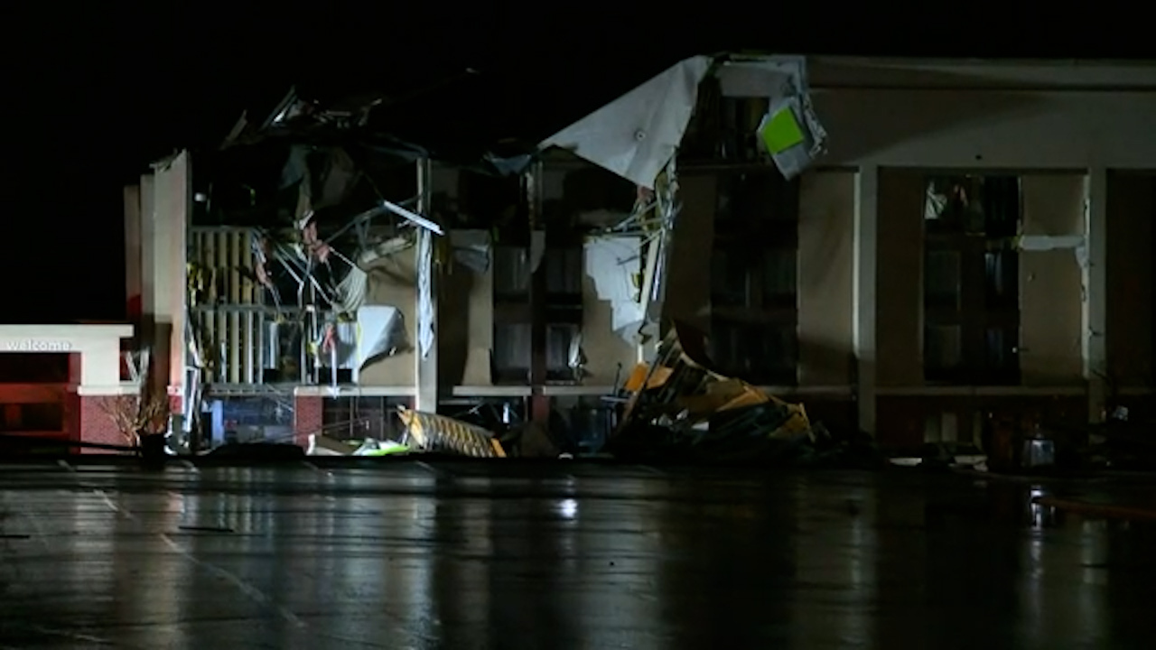
Video footage shows that the Hampton Inn in Fultondale, which is located just north of Birmingham and has a population of around 9000, according to census data, sustained significant damage during the storm.

It has been reported that guests staying at the hotel were able to escape the building and sought shelter in a nearby restaurant when another line of storms came through.

NWS Birmingham said in a tweet, they are monitoring reports "after a tornado impacted the Fultondale area of Jefferson Co. a short time ago."

"Significant damage has been reported. We will inspect the damage to determine the strength of the tornado."

https://twitter.com/NWSBirmingham/status/1353939999302045697?s=20

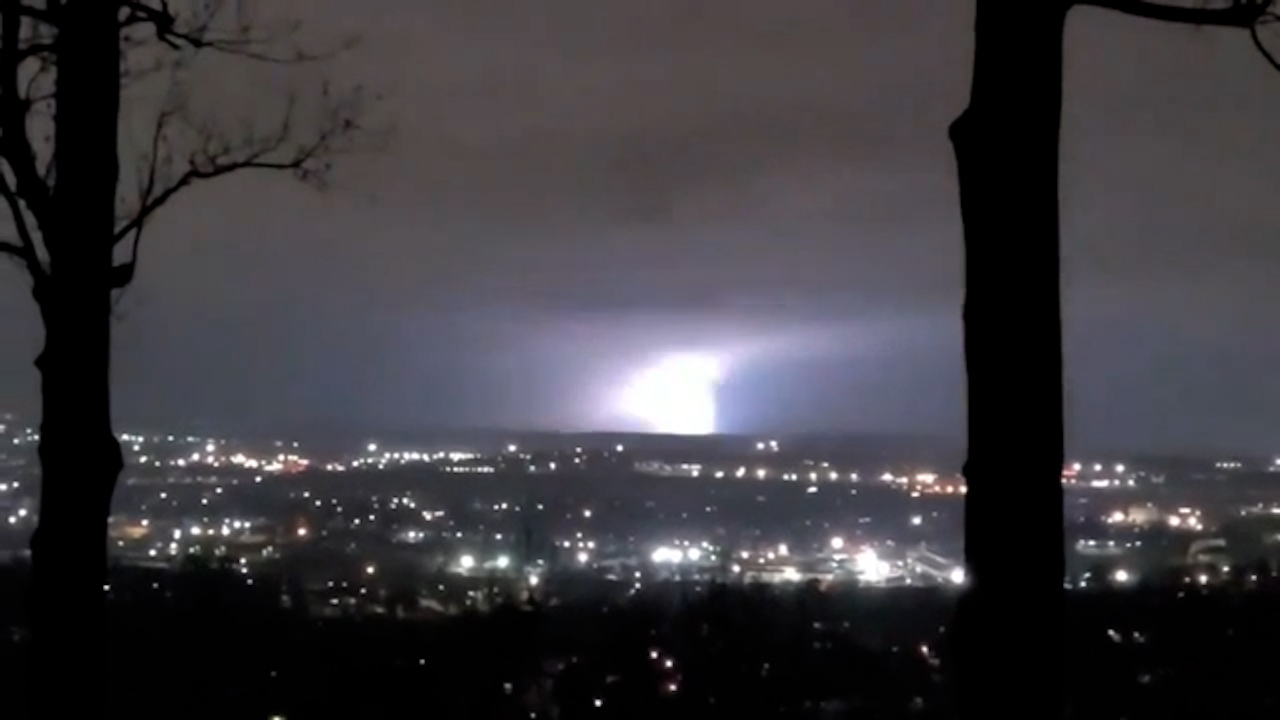
"At 10.54 PM CST (3.54pm AEDT), a confirmed large and extremely dangerous tornado was located over Chalkville, or near Trussville, moving east at 50 mph (80.5km/h)," the agency said earlier on Twitter.

About 21 kilometres northeast of Birmingham, the city of Centre Point, which has a population of more than 16,000, also saw "quite a bit of damage" from the storm, Mayor Bobby Scott said.

Mr Scott said that the back half of Hilldale Baptist Church's roof is missing, and the city's recreation centre also suffered damage in the storm.

"Looks like we will have a long day ahead of us tomorrow," Mr Scott said.

"Hopefully we can get everything covered up.

"We don't have any injuries to report right now so we're definitely grateful for that."

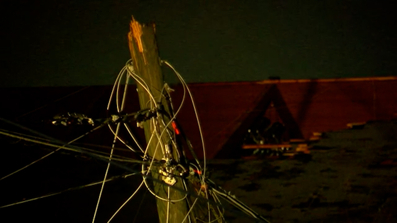
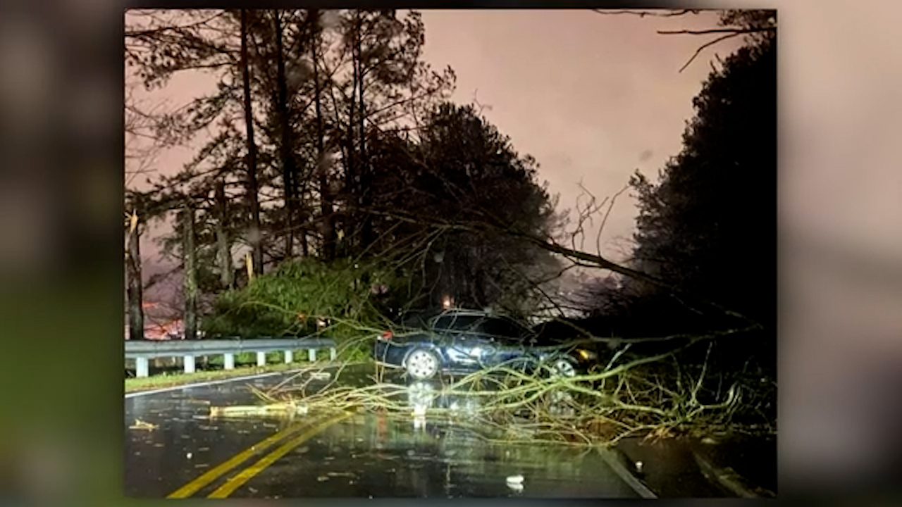
The Jefferson County EMA has asked people to stay out of the area as first responders try to reach the most damaged locations.

"On top of road dangers such as power lines and debris … traffic is clogging the roads," Jefferson County EMA said on Twitter.

Eleven schools in the area will be closed for both in-person and virtual learning Tuesday following the storm.

https://twitter.com/EMAJeffCoAL/status/1353961918210387968?s=20

Tornado warnings in effect through Tuesday morning

A tornado warning was issued Monday night for Jefferson County, Alabama, NWS Birmingham said in a tweet.

The agency has since issued tornado warnings and watches for several counties as the line of storms moves northeast through the state.

A tornado watch remains in effect for parts of Alabama and Georgia.

The line of storms is part of one of two larger systems that has more than 100 million people under winter weather alerts.

The storm will dump significant snow from the Central Plains to the mid-Atlantic Coast through Tuesday night.

The deepest snow will pile up across Iowa.

Some of the snow will be very heavy, with rates of up to five centimetres an hour, according to the Weather Prediction Centre.

Body recovered from Murray River in desperate search for man feared drowned

The body of a man has been recovered from the Murray River this evening, hours after he got into difficulties whilst swimming in a popular waterhole in Victoria's north.

Emergency services were called to Thompsons Beach on the Muarry River near Cobram at about 1pm today following reports the man went under the water and didn't resurface.

Members of the SES, Victoria and NSW police as well as member of the public joined the search for the man feared drowned.

At approximately 8.40pm, members of the Victorian Police Dive Unit located the 35-year-old submerged in four-metres of water, and he was declared deceased.

Authorities told 9News the man, from St Kilda, was on holidays with friends when the incident occurred.

"Friends entered the water here at Thompson beach and proceeded to swim across the river. However, on the way across one of the males came into some difficulties and sunk beneath the surface," NSW Police Acting Inspector David Forland told 9News.

"His friends were not able to help him at the time."

Witnesses say the man was taken by the current of the river.

"Everyone was having fun… and unfortunately this sort of thing can happen to anyone really," one witness, Peter, told 9News.

"He was swept down on the embankment over there on the other side and was last sighted right near this small boat," another witness said.

The incident comes after a deadly start to the year for swimmers, with seven people drowning in the past two weeks in Victoria and NSW.

Sydney endures hottest Australia Day since 1960

Sydney has endured its hottest Australia Day in 61 years as residents swelter through a summer heatwave.

Data from Weatherzone shows today is the hottest January 26 since 1960 after the mercury hit 37.1C at 12pm.

Sydney Airport recorded a temperature of 40.2C at 1pm.

"Sydney has also achieved its hottest spell in 10 years, averaging a maximum of 33.5 degrees for the last five days. Most of western Sydney west from Bankstown has been averaging 36-39 degrees but had a hotter five-day spell last summer," Sam Brown from Weatherzone said.

"The very hot airmass is being drawn from inland across the region ahead of a low pressure trough moving in from the west."

Thankfully today is forecast to be the last of a five-day heatwave.

"This Australia Day marks the last day of heatwave conditions which has scorched parts of NSW," the Bureau of Meterology's Agata Imielska said.

A maximum of 36C was predicted in the city today as thousands flocked to beaches and into the city for planned Invasion Day protests.

"It's not just a one-off day of heat, the sort of heat on its own wouldn't be a worry for most people but its been a spell of building heat and it's probably starting to take its toll for some people," meteorologist from Weatherzone Brett Dutschke told nine.com.au.

Elsewhere, parts of Queensland are also expected to swelter while a new wave of heat begins in Western Australia.

While a cool change has arrived for South Australia and Victoria, several states remain on high alert today.

"As that cool chance moves through we will see temperatures cooling and some light shower activity," Ms Imielska said.

"But the key message is today is still a dangerously hot day. It's really important people take the right protective actions."

Ambulance services have urged people to remain vigilant and look out for friends and relatives.

"We're getting an increased amount of activity as a result of heat related conditions, anything from heatstroke to collapse and the heat playing havoc with people with pre-existing conditions," NSW Ambulance Inspector Giles Buchanan said.

Dangerous surf conditions and crowded beaches are adding to the concerns of emergency services after more than 250 rescues were conducted on Sunday.

"We're having an increased number of calls to drownings, we've had 47 drownings or near drownings since Friday which is a devastating number," Mr Buchanan said.

New South Wales Surf Life Saving (NSWSLS) has predicted today to be "the most operationally challenging days that we've had in the last five years," NSWSLS member Matt Spooner said.

"The sun is hot, the surf up and surf lifesaving resources are being tested."

Surf conditions are remaining rough today due to strong winds around the NSW coast, particularly around the Sydney and Illawarra region.

The BoM has warned of "unpredictable conditions" with dangerous currents and large swell for several areas.

"For anyone considering going out on the water we are expecting those sea breezes to be stronger than usual," BoM meteorologist Agata Imielska said.

https://twitter.com/slsnsw/status/1353859913873723392

People have been warned to take extra precautions to protect themselves from heatwave conditions and dangerous surf.

"Our clear message to people on the coast is alcohol and swimming do not mix," Mr Buchanan said.

"Please, we want to make sure everyone comes home to their loved ones safe after a busy Australia Day and our life savers are not put in harms way."

Here's how the heat could impact your state this Australia Day:

New South Wales and ACT

Heatwave conditions are forecast to reach their peak across NSW today, with the hottest temperatures forecast in Sydney's west.

"Today will be the hottest day over the five day hot spell for the Sydney area," Mr Dutschke said.

"In Sydney far western suburbs get past 40C today, could get as hot as 41C in some places."

READ MORE: 'Busiest day of year' for beaches as heatwave scorches Australia Day

"Those temperatures will be as much as 10C or 11C above average, so it's noticeably hotter than normal."

"Given that it's likely to 35C today, it'll be a maximum average of at least 33C for the last five days and that's effectively going to be the hottest spell in ten years."

Penrith was 40C yesterday, looking to be 41C today. Richmond and Campbelltown are among many of the places are likely to get into the forties, along with much of northern NSW.

READ MORE: Sydney Opera House lights up for Australia Day

The central western slopes and plains will be above average today with daytime maximum temperatures between 35C and 40C in most parts.

Further inland, Dubbo is set to reach 38C just behind Bourke 39C.

Canberra will we well above average with sunny conditions and a top of 35C. There is a high chance of showers in the ACT this afternoon with the chance of a thunderstorm in the early evening.

Queensland

The heatwave has eased for most parts of the state however western Queensland is in for another day of severe heat.

"The hottest area will be Western Queensland where it's getting to into the low forties that includes Birsville and Windora."

Brisbane will be hot with a top of 30C however this is less than 1C above average for January.

Western Australia

While the heat is set to ease for the eastern parts of the country, it's only just beginning for the west with WA forecast to swelter through a low to moderate-intensity heatwave from today.

The hottest part of the country is expected to be Pilbara today where temperatures are set to soar above 43C.

"This heatwave its losing intensity and from here on its just going to be confined to northern NSW and Western Queensland for the next few days and become low intensity whereas in Western Australia, there's a heatwave just beginning in the north west of the state and that will extend down parts of the west coast over the next several days," Mr Dutschke said.

Perth is likely to dodge the extreme conditions this week however next weekend could bring temperatures well into the mid to high thirties.

https://twitter.com/weatherzone/status/1353574706058653698

South Australia and Victoria cool down

After four days of severe conditions, a southerly change has arrived in the south of the country causing temperatures to plummet.

"The heatwave is effectively over for South Australia and Victoria. A cooler change has come through and they've had some rain so it's well and truly over," Mr Dutschke said.

After temperatures reached around 37C on Sunday afternoon, the mercury reached 38C in some parts of Victoria by 10:30am on Monday.

In Melbourne, Laverton recorded the city's hottest temperature, reaching 41.5C at 12:40pm.

A cool change that began in the state's south-west was not expected to reach Melbourne until 5:00pm, but moved quickly to arrive much sooner than forecast.

The temperature at Avalon dropped by 10C in the space of an hour.

Cool and drizzly conditions are expected for Melbourne today with maximum temperature of 22C while Adelaide is unlikely to get hotter than 24C.